10 Incredible Cloud Formations Which Look Fake But Aren’t
Have you ever lied down on the field and watched clouds transforming into different shapes and sizes? Scroll below to explore some interesting cloud formations.

What was your favorite summer activity when you were a kid? Well, my favorite activity was to watch the clouds turning into different shapes of dragons, Mickey Mouse and other amazing creations. You can also experience the amazing cloud formations but only if you can observe the change in their patterns in the sky.
Cloud formations are one of the most romantic gestures of nature but these visible masses of liquid droplets sometimes also create interesting visual phenomena. Unless you are a serious cloud watcher, you may have never thought of different types of clouds and patterns that are formed in the sky. Regardless of the size and shape, the clouds are made of the same thing – either ice or condensed water.
Most of us have never got the chance to watch the amazing cloud formations. You are lucky if you have watched some of the unbelievable cloud formations. In fact, some shapes are so rare that they are formed once in the blue moon. What’s more surprising is that each cloud shape has its different meaning.
Even though the different shapes of clouds might seem indescribable to you, there’s a huge cloud classification system that is common worldwide. So, here is a quick compilation of some stunning cloud formations that you might have never seen before.
1. Lenticular Cloud
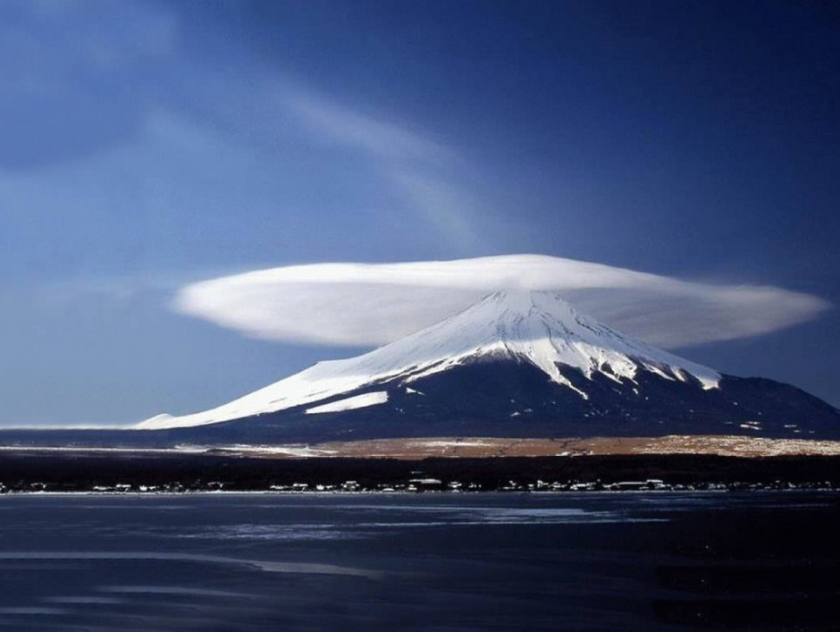
Lenticular Cloud is obviously a bizarre cloud type that is usually formed in the troposphere and remains perpendicular to the wind direction. These kinds of clouds include both natural and man-made features of the Earth such as hills, buildings and other structures. The formation of the lenticular cloud is very rare. So when you see one, don’t forget to capture it in your camera. (18.1)
2. Clouds That Resemble Ocean Waves
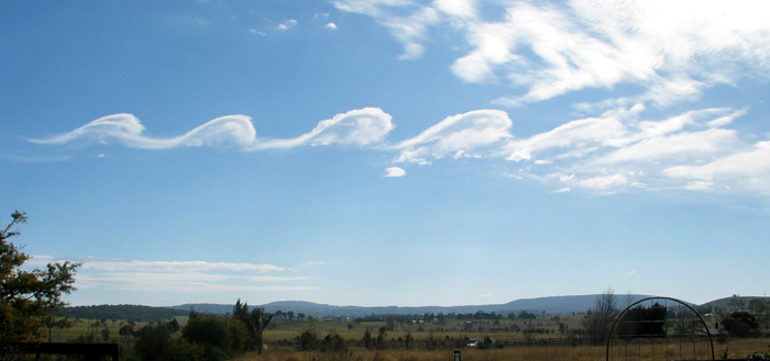
Often referred to as Kelvin Helmholtz clouds or billow clouds or shear gravity clouds, they occur when there is a velocity difference across the interface between two fluids. The clouds look like breaking ocean waves. You will often see these clouds when two different layers of air are moving at different speeds.
3. Roll Cloud Hang Glider
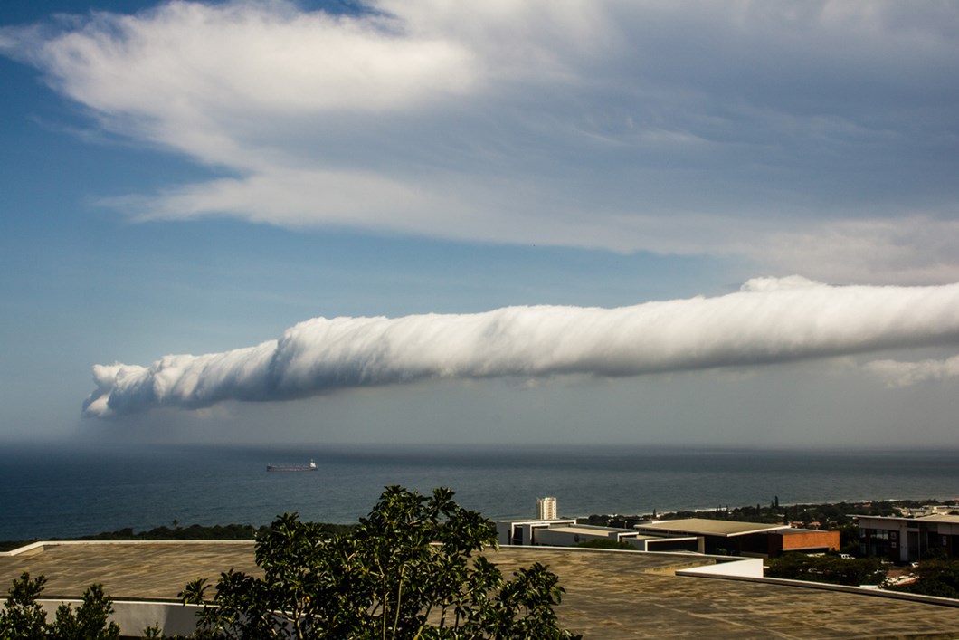
It is another stunning cloud formation in which cloud is seen in tube-shaped rollers. The clouds in Roll cloud completely detach from the cloud bodies and appear to roll as they move across the sky. They are often related with the cold fronts and are usually low and tube-shaped.
4. Mammatus Cloud
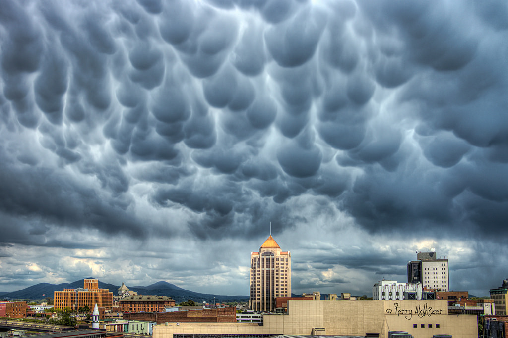
Mammatus Cloud is a pattern of pouches hanging underneath the base of the cloud. The clouds look like they have been attached to their parent clouds. Mammatus Clouds are often noticed after the thunderstorm has passed. They occur in the group and look amazingly beautiful together. Usually, these kinds of clouds are composed of ice, but in some cases, they can also be a mixture of liquid water and ice. Have you ever noticed this stunning formation?
5. Mushroom Cloud
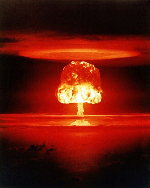
A mushroom-shaped cloud is the result of the sudden formation of lower density gases at any altitude. It is a distinctive cloud of smoke and consists of condensed water vapor that results in a large explosion. The mushroom cloud is directly associated with nuclear weapons and any of the large blasts including meteorite impacts or volcanic explosions.
6. Punch Hole Cloud
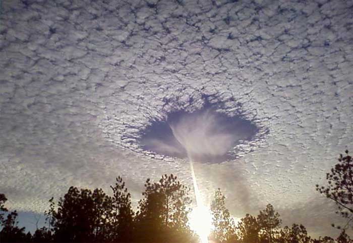
Punch Hole Cloud, commonly referred to as Skypunch or fallstreak hole, is a large gap usually elliptical that appears in the altocumulus clouds. It is assumed that the introduction of tiny crystals into the cloud layer creates this domino effect and forms the hole. This amazing cloud formation is often linked with UFO sightings. These are also the rare ones but when you notice one, please do not assume that aliens are coming to meet you!
7. JellyFish Clouds
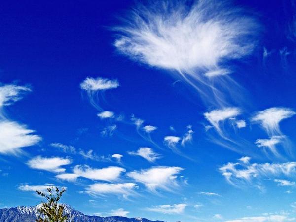
The tentacles of these kinds of clouds usually hang down vertically just like in the case of jellyfish. It is not an official cloud type but is the perfect description of jellyfish appearance. The solid part at the top of cloud looks like the jellyfish's body and the wispy portion extends vertically towards the ground. The Jellyfish clouds or Altocumulus clouds are often noticed 7000 to 25,000 feet above the ground and mostly in the United States.
8. Shelf Clouds
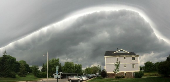
A shelf cloud is well-defined, low hanging and remains attached to the base of the parent cloud. Apart from being incredibly beautiful, these kinds of clouds are newsworthy because it makes people threatened of thunderstorms. People often mistaken it for tornadoes.
9. Nacreous Clouds
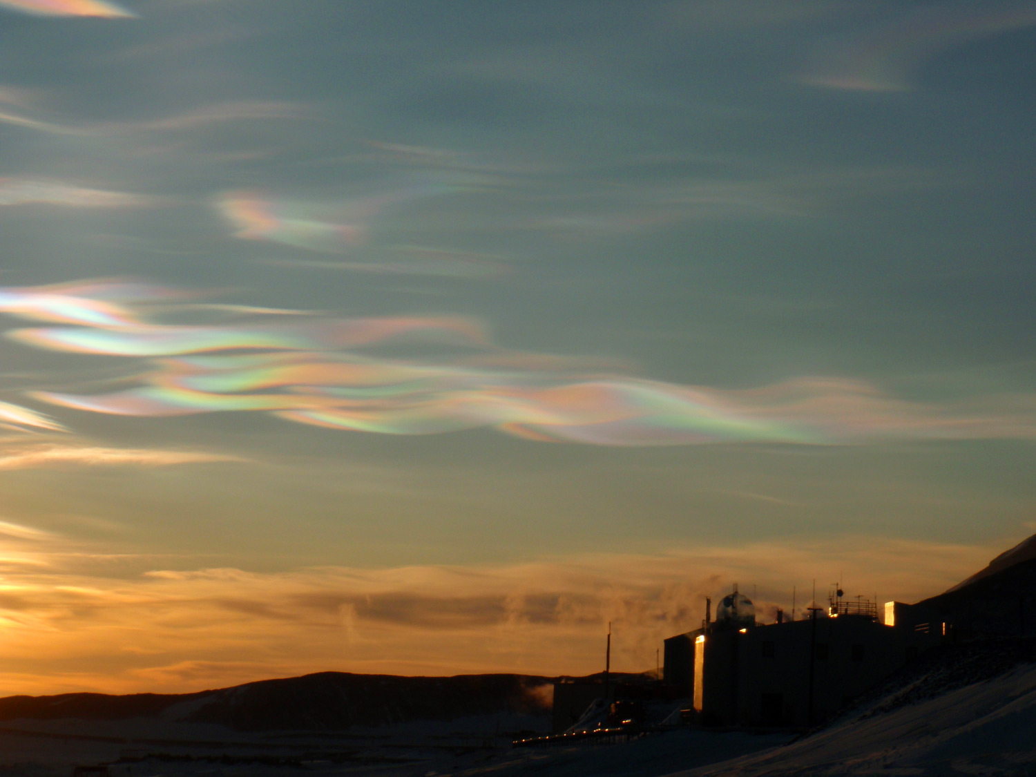
Nacreous clouds or Type II Polar Stratospheric clouds or mother-of-pearl clouds are very rare and but once noticed, they can never be forgotten. These amazing transformations of clouds are visible within two to three hours before dawn and are better known for iridescent colors. They are seen during winter in Alaska, northern Canada and Iceland.
10. Cumulonimbus Capillatus
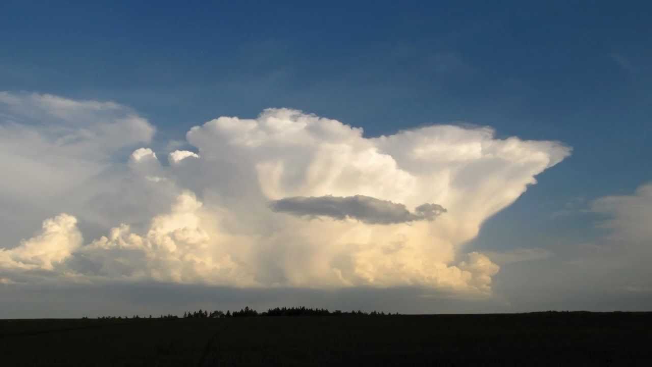
Cumulonimbus capillatus are different due to the appearance of the clouds summit which can reach over 15 kms into the sky. Once it is developed, it often grows in the ice-crystal locks of the capillatus. It is often characterized as the flat, anvil-shaped top with circus cloud that contains hair-like structures.
Popular Posts
20 Most Powerful Goddess Names In Mythological World
From Gaia to Kali; every goddess in mythologies have a prominent role to create or restore the balance in nature and the universe.
Kimberly Campbell
21 Gods & Goddesses of Destruction, Death & Underworld
This list showcases the Gods of death, the Underworld, and destruction: from the Egyptian God of Death- Anubis, who was recognized as a man with a jackal head, to the Hindu God of Death- “Yama,” who took the records of each person’s death. But Thanatos was the personified spirit of non-violent death.
Rupesh Chhabra
14 of the Renowned Gods and Goddess of Healing & Medicine
No wonder, the God of healing and magical tradition allied to it, never failed to surprise people especially in ancient times. Let’s discover some of God and Goddess of healing and their amazing contribution.
Rupesh Chhabra